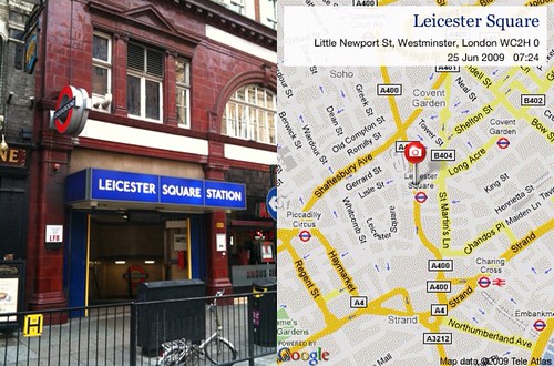
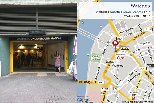
There is an iPhone app called GPS Map Cards [web link] [app store link] which a few of us have been obsessed with over the last few months. Essentially it does this.

Which is great and everything, but I thought it might be fun to take pictures of Tube stations and map them accordingly. Like this.
The internet being the internet, other people started doing it too. Like Blech.
And so we started a Flickr Group. You can see the group here. Let's see if we can collect all 270 tube stations. That would be skill.
The group has some rules, like this.
1. Only take a picture of the front of the station with the name clearly displayed.
2. Match this up with the location on the GPS Map Card map.
3. Only use pictures taken with the GPS Map Card iPhone app.
4. Check if your station has already been included. Duplicates will be deleted. The rules are unashamedly strict and I will delete pictures that don't meet the criteria.
Here's a map of all the ones we've got so far.

Would you like to join in? Sign up to the group here.

'That would be skill' that's almost 80's hip hop talk mate, now that would be ill! Or as Run DMC once said you be illing!
Posted by: Russell | Sep 17, 2009 at 12:58
This would be much more interesting if one person took a photo of all 270 stops. Better yet if they were in the photo themselves.
Posted by: Neil Martin | Sep 17, 2009 at 22:21
Neil: pay for my travelcard extensions past zone 4 and I'd probably do it. Except for the self-portraits. That'd be way more expensive.
Posted by: Paul Mison | Sep 20, 2009 at 21:08
Bloody saucers.
Posted by: Justin | Sep 22, 2009 at 00:29
Exactly Justin!
Posted by: Ben | Sep 22, 2009 at 09:51